Drone & Aerial Photo Editing Services
Roomagen Aerial Photo Editing is an AI-powered drone image enhancement tool that corrects exposure, color balance, and distortion on aerial and drone photos. Used by real estate agents, hotel managers, commercial property owners, photographers, and drone operators, the output is a professionally enhanced aerial shot with balanced lighting and accurate colors. Processing takes 10-20 seconds using 1 credit per image ($0.12–$0.13 depending on plan), with a free plan offering 6 credits.
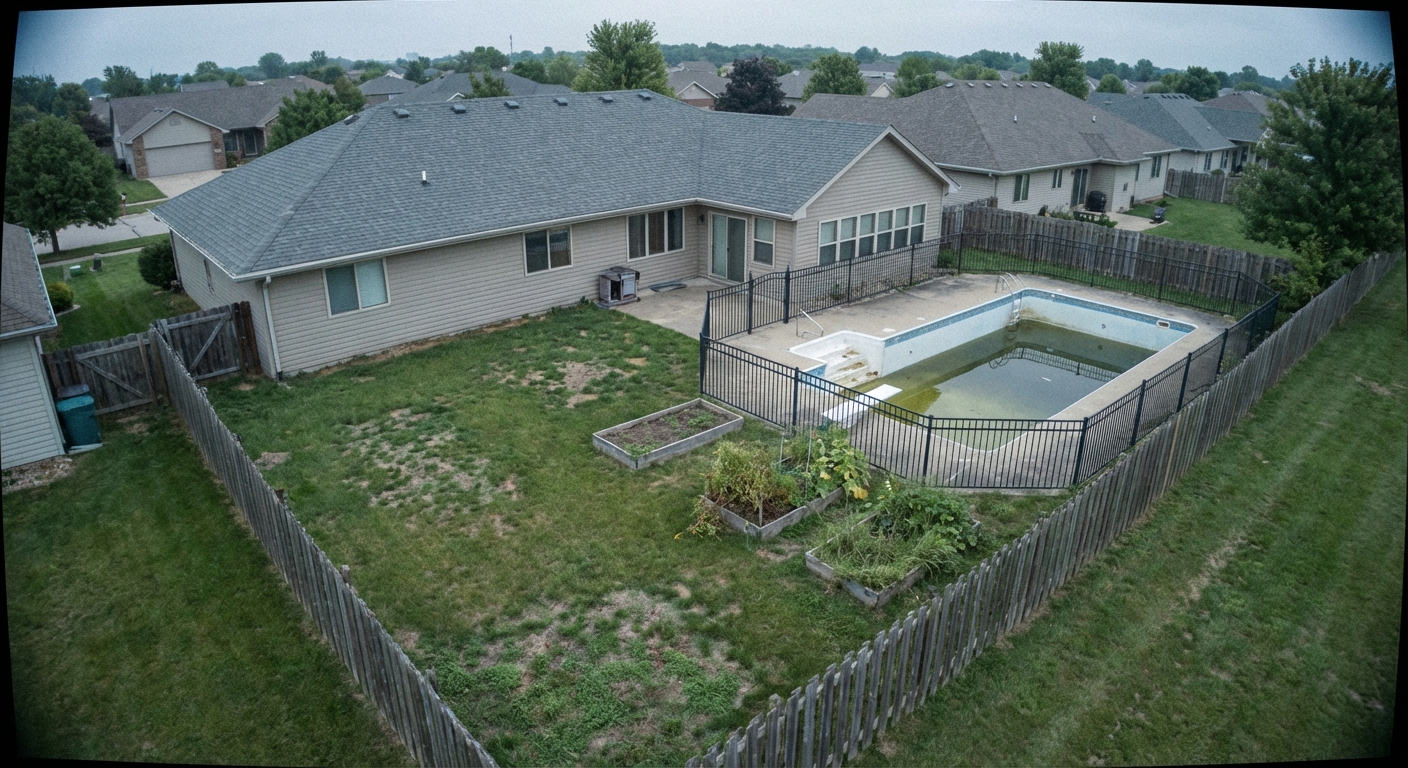
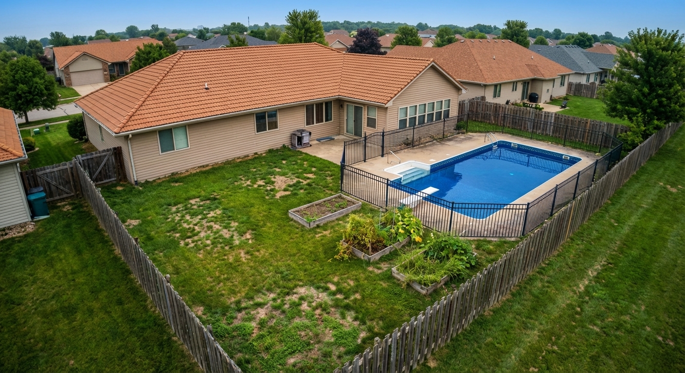
Drone photography has become standard in property, hospitality, and commercial marketing but raw drone footage typically requires extensive post-processing — color correction for atmospheric haze, white balance adjustment for varying altitudes, removal of unwanted objects, overcast sky replacement, and seasonal corrections. Properties, hotels, and commercial buildings with professionally edited aerial photos receive 68% more online views than those with unedited drone captures. Professional drone photo editing costs $50-150 per image with 1-3 day delivery, and each editing request is often priced separately — sky replacement, object removal, and color correction are billed individually. The wide field of view captures uncontrollable elements — neighboring structures, cluttered streets, construction sites, and seasonal vegetation issues all appear in aerial shots regardless of pilot skill. Roomagen AI provides comprehensive drone photo editing — sky replacement, object removal, color enhancement, lens correction, and seasonal adjustments all processed simultaneously in a single operation under 90 seconds for 2 credits.
No credit card required. Results in 30 seconds.
Features
Professional drone and aerial photo editing: enhancement, sky replacement, color correction and object removal. Fast AI results for real estate exteriors. 6 free credits, no sign-up.
Enhance Drone Photography
Enhances drone photos with color correction and sky replacement
Aerial Sky Replacement
Overlays property boundaries and lot dimension markers
Property Boundary Highlights
Processes RAW files from DJI and all major drone cameras
How It Works
Get professional results in three simple steps
Drop your photos here
or browse files
Upload Your Photos
Simply drag and drop your photos or browse to upload. We support all major image formats including JPG, PNG, and RAW files up to 50MB each.
Upload a drone photograph — any angle including bird's eye, 30-60 degree tilt, and horizontal perspectives at any altitude and weather condition. The AI analyzes the drone perspective of the image — lens distortion, wide-angle effects, and horizon tilt are diagnosed automatically. Property boundaries, surrounding areas, sky regions, and unwanted objects are identified and marked separately for targeted editing.
AI Processing
Our advanced AI analyzes your images and applies professional enhancements automatically. Choose from virtual staging, enhancement, object removal, or day-to-dusk conversion.
The AI applies comprehensive editing — sky replacement from overcast to blue sunny skies, unwanted object removal including cars, trash, and construction materials, color enhancement with HDR-like dynamic range expansion, grass and landscape color revitalization, and lens distortion correction. All corrections are applied simultaneously and cohesively — complete enhancement in a single processing step.
Download Results
Preview your transformed images and download high-resolution results ready for listings, marketing materials, social media, and more. No watermarks on premium plans.
Processing completes in under 90 seconds. The photorealistic output features natural-looking sky, seamless fill where objects were removed, and vibrant yet natural colors. The result is listing-ready drone photography of professional quality. Combine with other tools for complete exterior enhancement — apply aerial editing first, then use landscaping or seasonal reset tools to perfect the property surroundings.
Why Choose Roomagen
Drone Image Enhancement
Enhances drone photos with color correction and sky replacement
Aerial Perspective Correction
Overlays property boundaries and lot dimension markers
Lot Line Visualization
Processes RAW files from DJI and all major drone cameras
Who Is It For?
Real Estate & Hospitality
Enhance aerial photos of properties, hotels, and resorts with sky replacement, color correction, and professional finishing.
Commercial & Architecture
Create professional aerial marketing images for commercial buildings, developments, and architectural projects.
Photographers & Drone Operators
Speed up drone photo post-processing with one-click enhancement that handles sky, color, and distortion correction simultaneously.
Common Use Cases
Drone Listing Enhancement
Enhance drone exterior photos with corrected exposure, vibrant colors, and balanced lighting. The AI is tuned for the unique characteristics of aerial photography.
Aerial Portfolio Consistency
Process all drone photos from a property shoot through the same enhancement for consistent color grading and exposure across the entire aerial photo set.
Property Boundary Showcase
Enhance aerial shots that show property boundaries, lot size, and neighborhood context. Clear, vibrant aerial photos help buyers understand the property’s setting.
Neighborhood Context Enhancement
Improve wide-angle aerial shots that show the property in its neighborhood context — proximity to parks, schools, amenities, and transportation.
Commercial Property Aerial Marketing
Transform drone photographs of commercial properties including office buildings, shopping centers, and industrial areas into professional marketing materials. Parking areas, landscaping, and building facades are enhanced in a single processing step for maximum visual impact.
Construction Progress Documentation
Clean up drone photographs of properties under construction — remove unwanted construction equipment, temporary structures, and scattered materials from the frame. Present clean progress photographs to investors and prospective buyers showing the property's potential.
Professional drone photo editors charge $50-150 per image with 1-3 day turnaround, and each editing request is typically priced as a separate job — sky replacement, object removal, and color correction are treated as distinct services with separate fees. DIY editing requires Lightroom combined with Photoshop and demands specialized drone photography editing skills. Built-in drone companion software from DJI, Autel, and other manufacturers is limited in scope and cannot perform object removal or sky replacement. Roomagen handles comprehensive drone photo enhancement — sky replacement, object removal, color correction, seasonal adjustment, and lens distortion fix — for 2 credits in a single integrated operation under 90 seconds.
| Roomagen | Professional Drone Photo Editing | |
|---|---|---|
| Cost | $0.12–$0.13 | $50–$100 per photo |
| Turnaround | Under 10 seconds | 15–30 minutes per photo |
| Skill required | None | Color grading expertise |
| Consistency | Automatic across all shots | Varies by editor |
| Batch capability | Unlimited | Time-consuming per image |
| Availability | 24/7 instant | Editor availability |
Technical Specifications
- Supported formats
- JPEG, PNG, WebP
- Max file size
- 50 MB
- Output resolution
- HD / Ultra HD (Business)
- Enhancement levels
- 3 (light, medium, heavy)
- Optimized for
- Drone and aerial property photography
- Processing time
- Under 10 seconds
- AI model
- Gemini AI
- Credit cost
- 1 credit per image
Pricing
| Plan | Price | Credits/mo | Per Image | Resolution |
|---|---|---|---|---|
| Free | $0 | 6 (one-time) | Free | HD |
| Starter | $8/mo | 60 | $0.13 | HD |
| Pro | $28/mo | 240 | $0.12 | HD |
| Business | $64/mo | 520 | $0.12 | Ultra HD |
Per-image cost = 1 credit. Annual plans reduce cost by ~17%. Credit packages: 60/$17, 180/$36, 360/$88.
Frequently Asked Questions
Everything you need to know about Roomagen
Explore Related Tools
Discover more AI-powered tools to enhance your visual content
AI Sky Replacement — Perfect Skies for Any Exterior Photo
Replace overcast or bland skies with stunning blue skies or dramatic sunsets. AI-powered sky replacement that looks completely natural — for property listings, hotels, commercial buildings, and any exterior photo.
Learn moreAI Photo Enhancement — Professional Quality in Seconds
Enhance any photo automatically with AI. HDR processing, color correction, lens fix, and professional-grade adjustments in seconds — for property listings, hotel rooms, product shots, and more.
Learn moreVirtual Landscaping Design
Virtually landscape any outdoor space with plants, trees, gardens, and features. Boost curb appeal for properties, hotels, resorts, and commercial spaces without breaking ground.
Learn moreExterior Home Rendering & Visualization
Create photorealistic exterior renders showing home improvements, new construction, or facade transformations.
Learn moreDay to Dusk Photo Editing & Conversion
Convert daytime exterior photos to stunning twilight images. Add warm interior lights and dramatic dusk skies that captivate buyers.
Learn more